Introduction
I'd never really considered Sandiacre to be a "village"
in the truest sense of the word and even when I looked it up
on dictionary.com I found a couple of definitions that seemed
to back my point of view. They were 1) a small group of dwellings
in a rural area, usually ranking in size between a hamlet and
a town and 2) a community of people smaller than a town.
Even after reading that, I would still have classed Sandiacre
as a small town - why even their local football team is called
Sandiacre Town F.C. But that is where I would probably have been
wrong. You see, the expansion of both Sandiacre and its near
neighbours of Long Eaton to the south, Stapleford to the east
and Risley to the west mean that its borders merge almost imperceptibly
into the others and give the overall impression of a much larger
place than it really is. Only the northern border to Sandiacre
is to open countryside and even then there is precious little
of it. But a village it is and has grown up around a sandy field
that gave rise to its name from the Old English of sand meaning
"sand" and aecer meaning"field". For the
purpose of this series, I shall once again be basing the route
on a "Village Trails" leaflet produced by a number
of organisations including Groundwork Erewash Valley, Derbyshire
County Council, the Erewash Museum, the Countryside Commission
and the Sandiacre Parish Council. The leaflet was printed in
1994 and such has been the pace of redevelopment and change that
I am not certain that I will find all the sites and sights mentioned
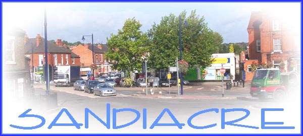
but we'll begin at the market place which can be seen in the
title image above from the junction of Longmoor Lane and Station
Road. The lorry is emerging from Town Street and the cars waiting
at the traffic lights are on Derby Road.
Update January 2009 - After publishing this series on
the internet in 2005/6 I was contacted by David Roberts, a former
resident of Sandiacre who now lives in South Wales. David was
inspired by the series to produce a document of his own following
the same route but recalling his childhood in the 1940/50 period.
Towards the end of 2008 David sent me a copy of his "Memories
of Sandiacre" and I have now incorporated the relevant parts
in popup windows on each page. The following is David's introduction
to the document.
"Memories Of Sandiacre" by D. W.
Roberts © 2008
As I approach my seventieth birthday I was intrigued to see pictures
of Sandiacre as it now is, on the Ilkeston Cam website. I lived
there from 1942 (of which I remember little) until 1954 when
my parents moved to College Street in Long Eaton. My father,
Jim Roberts, was moved during World War II to be an electrician
at Stanton (which meant the very extensive Ironworks in those
dark days of the War) and my mother, whom some may remember,
was Mrs. Clarice Roberts who taught first at the Top School (then
situated between Lawrence Street and Church Street) under the
headmastership of Mr. Parrott and later at Victoria Road infants
under Miss Cole, the headmistress who rather disapproved of married
teachers. I do wonder which particular teacher the authorities
had in mind when they renamed the school "Ladycross";
perhaps it would be unkind to suggest that they had Miss Spenser
in mind?
Enough of me; what I propose to do is follow the Village Trail
of 2005 section by section, and describe, as best I remember
them, the differences to be seen if the wanderer were carried
back to about 1950. There will also be the odd anecdote of those
days, which some may find tedious. (Not at all David)
I suppose the first thing to say about the village is that in
1950 there were few people with cars. I heard it said, "You
can have children or you can have a car, but only the rich can
have both." Living, as we did, on the end of Ilkeston Road,
the men coming home from Stanton Ironworks were mostly on bicycles,
with a fair number walking and only a small number in cars. This
means that many of the streets we see would have had much less
clutter in terms of parked cars. Naturally there are many new
buildings, and even new roads, yet much of Sandiacre is little
changed from my time there. Among the new roads are the new motorway,
and the "new" A52; in the time of which I speak motorways
were only dreams in the minds of planners, and traffic from London
to the north went up the A6 through Shardlow and Derby. All Derby
to Nottingham traffic followed the A52 through Risley, Derby
Road, Sandiacre Market Place and Station Road to Stapleford,
so that was, even then, a busy road.
To read David's "Memories of Sandiacre" in conjunction
with each part click the link beneath the title image on each
page.
|