Ilkeston - Up High
But Close
w/e 13 August 2006
All
this week's pictures were taken with a Kodak DX6490
This page contains another selection from my trip
to the top of St Mary's Church tower but all of these resulted
from the use of the zoom facility on the camera to give a closer
view of the subjects.
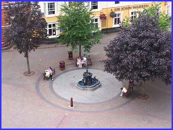
The fountain incorporating a horse trough in the north west corner
of the Market Place was erected in 1889 to commemorate the creation
of Ilkeston Borough two years earlier but it is many a long year
since horses made use of this facility. Nowadays it provides
a focal point where people can rest their weary legs for a while.
We have become accustomed to being watched by CCTV cameras in
our town centres but this view gives a whole new meaning to 'spy
in the sky' as I doubt that anyone in this image was aware of
my presence above.
|
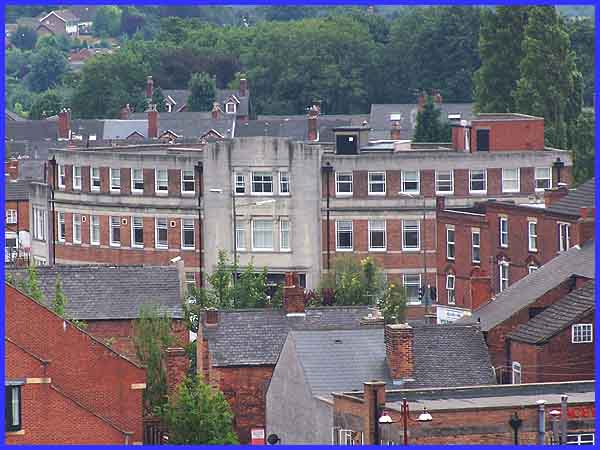
Local architect Harry Tatham-Sudbury, was responsible for many
of the notable buildings in the town including Toll Bar House
which was built for the Derbyshire and Nottinghamshire Electric
Power Company at the end of the 1920s. The top storey was added
in 1937 and for a number of years in the 1970s and 80s it was
from there - my desk was next to the first window to the left
of the central section - that I could see St Mary's Church on
a daily basis. It makes a change to be looking in the opposite
direction.
|
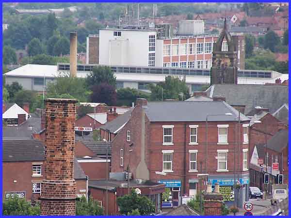
The Catholic Church and the South East Derbyshire College were
easily identifiable from from the top of the tower but a closer
look at this picture reminded me of a number of changes that
have taken place on Nottingham Road since my youth. For example,
people of my vintage may well remember Hoyes' sweet shop where
the white gable with the black sign is on the left while the
new building visible just to the right of the Rutland Garments
chimney was the site of Graham Garage and Shentall's grocery
shop. The three story building in the foreground where you can
now top up your sun tan was Greenaway's and the Co-Op Funeral
Parlour next door to the left was Aldred's Bakery shop and the
bakery itself was further to the left on Park Road.
|
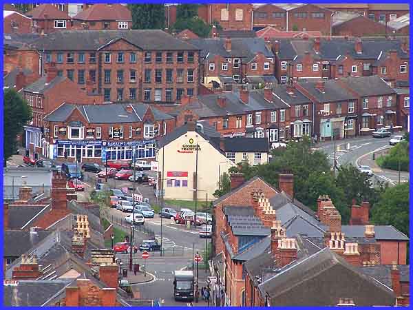
Whilst the differences on Nottingham Road are mainly due to a
change of ownership or occupancy those at the 'Bottom Of Town'
have been much more drastic. Properties have been demolished
and road layouts altered to allow for the inner relief road traffic
island at the northern end of Chalons Way. In this view, Bath
Street continued to the junction of Heanor Road (left) and Granby
Street and although the name plate for Bath Street still exists
on the 'George's Tradition' fish and chip shop, in practice the
alterations mean that the street now ends where the one-way system
starts as indicated by the 'No Entry' signs.
|
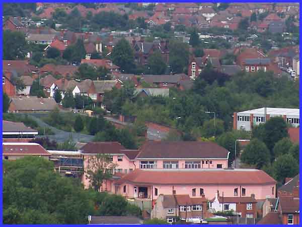
Heanor Road is also visible here where the walls of the bridge
over the former railway line can be seen immediately above the
pink building that is the headquarters of Weleda (UK) Ltd, the
anthroposophic and homeopathic medicine company. To the left
of the bridge on the former site of Ilkeston North Railway Station,
the town's new Police Station has been built. The railway station,
opened on 1 April 1878 by the Great Northern Railway as part
of the Derbyshire and Staffordshire extension, closed in the
1960s.
|
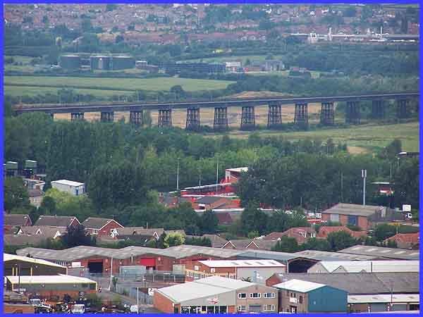
The railway line connected Derby and Nottingham and crossed the
boundary between the two counties, the River Erewash, over the
Bennerley Viaduct. The viaduct which is one of the last remaining
wrought iron lattice-girder bridges in the country was built
in 1887-8. Sixteen spans carried the line for over a quarter
of a mile across the valley on 56ft. high piers and it is now
a listed building. Bennerley Colliery once stood behind the viaduct
but this has long gone and the tanks to be seen now are the sewage
works at Newthorpe with Newthorpe and Eastwood (author D.H.Lawrence's
birthplace) beyond. Above the industrial units in the foreground
a corner of the New Manor Ground can be seen, the home of Ilkeston
Town Football Club.
|
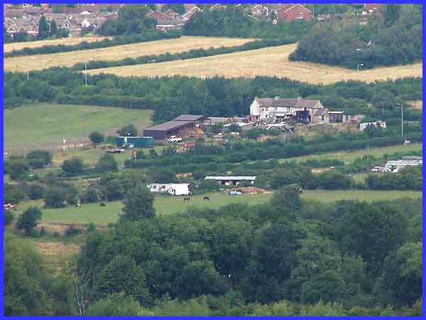
Although Ilkeston is Derbyshire's second largest town, the countryside
is never very far away and farming landscapes have replaced the
collieries that once imposed themselves on the area. This is
Bridge Farm which backs onto the disused Nottingham Canal and
the Willoughby
Top Cut that we visited recently. We can also see the houses
at Awsworth in the background and also another railway line (this
one is still in use) towards the bottom left of the image. This
is one of the main routes connecting the north and south of the
country and runs at this point along the Erewash Valley at the
side of the river.
|
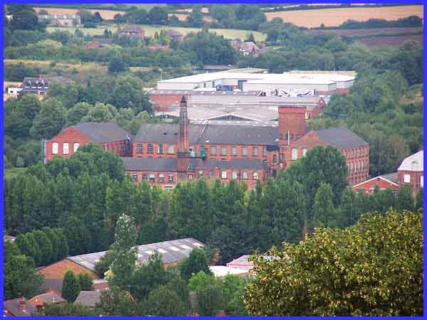
The trains using this line now speed through without stopping
at Ilkeston although there are moves afoot to reintroduce a local
station but before Dr Beeching wielded his axe in the 1960s,
the station at Ilkeston Junction was between this old mill and
the newer industrial units beyond. Those units occupy the site
of the former Cossall Colliery and Armstrong's Mill is well know
as an outlet for clothing open to the general public. Ilkeston
is not the most picturesque area of the UK by any stretch of
the imagination but for me this one picture captures the essence
of the area - a mixture of architecture with old sitting alongside
new, industry and agriculture, one foot in the past and another
heading into the future, town and country. St Mary's Church has
stood in the Market Place for a long time and the church tower
was repositioned in its present location about 100 years ago
- I wonder what the views from here will be like in another hundred
years.
Return to Page
1
|
