Sawley - Conservation Area Plus
w/e 04 October 2020
All of this week's pictures were
taken with a Kodak DX6490
At the time of the Domesday Book, Sawley was
the most important village in the area and was situated at a
strategic crossing on the northern side of the River Trent. By
the early nineteenth century agriculture was the most important
means of occupation but then lace working and stocking weaving
took over and the adjacent Long Eaton began to expand at the
expense of Sawley. In 1982 however, the village centre of Sawley
was designated a Conservation Area and it now includes several
listed buildings, some of which are shown below. Eight of the
ten images are also within the Conservation Area.
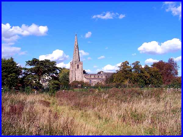
Seen here from the banks of the River Trent is the oldest surviving
building in the village, All Saints' Church. This dates from
the thirteenth century, has Saxon and Norman remains, mediaeval
stalls and monuments to the de Bothe (apparently pronounced Booth)
family. To the east (right) of the church, aerial photography
discovered an earthwork that is thought to be the remains of
a small Roman fort although it is not the usual size and shape.
Three fragments of Roman pottery were found in trial excavations.
|
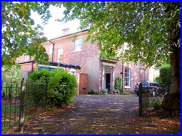
The Old Rectory which stands adjacent to the church is one of
the listed buildings in the Conservation Area.
|
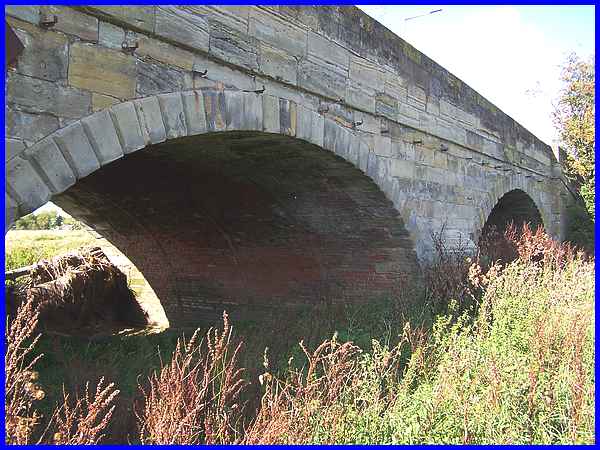
 Also Grade
II listed are two sections of the Harrington Bridge which crosses
the river. The stonework dates from 1790 when the bridge designed
by Thomas Harrison of Lancaster replaced the ferry across the
river. Originally a toll bridge with toll houses each end, it
became free to use in 1882. Flood water caused damage in 1904
and the central section had to be replaced in 1905/6. It is only
the central part of the bridge (right) that is not a listed building.
The bridge is named after the Lords of the Manor who were the
Earls of Harrington. In 1779, this was Charles Stanhope, the
3rd Earl. Also Grade
II listed are two sections of the Harrington Bridge which crosses
the river. The stonework dates from 1790 when the bridge designed
by Thomas Harrison of Lancaster replaced the ferry across the
river. Originally a toll bridge with toll houses each end, it
became free to use in 1882. Flood water caused damage in 1904
and the central section had to be replaced in 1905/6. It is only
the central part of the bridge (right) that is not a listed building.
The bridge is named after the Lords of the Manor who were the
Earls of Harrington. In 1779, this was Charles Stanhope, the
3rd Earl.
|
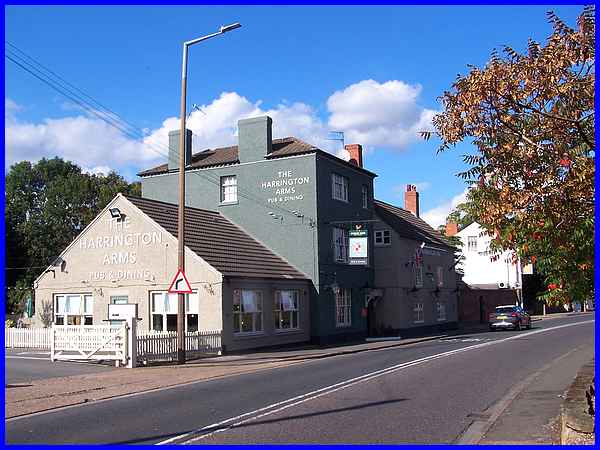
The Earls also give their name to The Harrington Arms, a coaching
inn on the northern approach to the bridge. Mail coach services
were introduced after the development of turnpike roads.
|
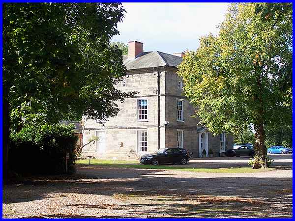
Coming from the south the road turns towards the north east and
Long Eaton after crossing the river and on the corner is another
of those listed buildings. Standing in its own grounds this is
the former home of the de Bothe family and naturally enough is
still known as Bothe Hall. Also on the corner an alley called
Wilne Avenue leads through to Wilne Lane near another listed
building, the Baptist Chapel.
|
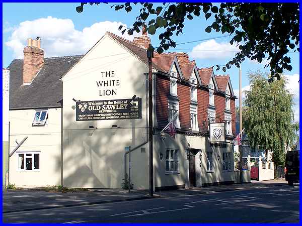
Just around the corner and opposite the drive to the church is
another pub. This is The White Lion and is the middle one of
three in close proximity along with The Harrington Arms that
were established to cater for the traffic travelling between
Nottingham and Birmingham. Another alley, Church Avenue, again
leads through to Wilne Lane.
|
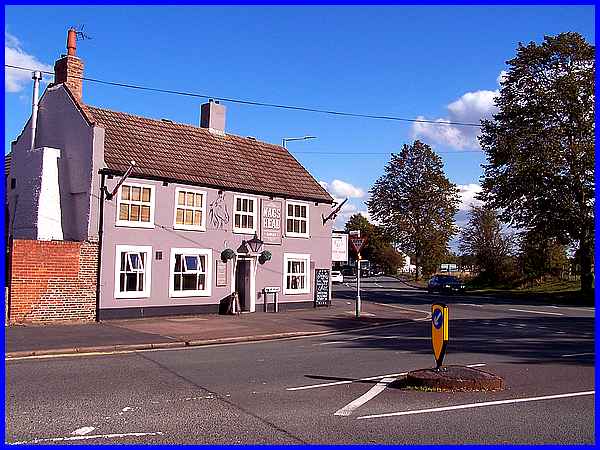
The third in the trio of pubs is The Nag's Head that stands on
the corner of Wilne Lane.
|
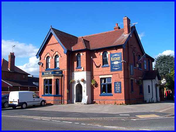
And turning into Wilne Lane leads to yet another pub. This is
The Railway Inn and this began life as a cottage but developed
into the inn to cater for railway travellers and served the nearby
Sawley Station. This is not included in the Conservation Area.
|
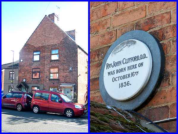
Neither are the two semi-detached houses opposite The Railway
Inn in the Conservation Area although the one on the left has
a plaque over the door indicating the birthplace of Rev. John
Clifford, D.D. in 1836. Dr. Clifford rose from being an apprentice
as a child in a large factory to study at university and later
was a great influence on several pieces of legislation relating
to education. He was also prominent in the Baptist Christian
Community. Church Avenue emerges from Tamworth Road to the right
of the house on the right.
(Read more about Dr Clifford at https://bit.ly/2SpUmJf)
|
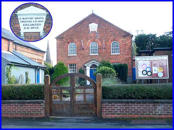
It's a little further along Wilne Lane that the other alley,
Wilne Avenue reaches Wilne Lane having passed behind the Baptist
Chapel. The chapel itself built in 1800 and enlarged forty five
years later does fall within the Conservation Area even though
Wilne Lane does not. It is also the last of the six listed buildings
in the area, the others being the All Saints' Church and the
Old Rectory, the two section of Harrington Bridge, and Bothe
Hall.
|
