Ilkeston (South) - Places of Worship
w/e 22 January 2012
All this week's pictures were taken
with a Kodak DX6490
In the set of images featuring the places of worship
in the northern half of the town we began at Cotmanhay and worked
our way towards the town centre. In similar fashion this selection
of images begins in the south at Kirk Hallam and then heads towards
the centre of Ilkeston.
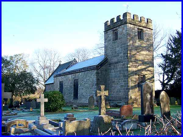
Although they are now areas of Ilkeston, both Cotmanhay and Kirk
Hallam were communities that developed into villages in their
own right back in the mists of time. When the Church of All Saints
was founded at Kirk Hallam in the late Norman period it was administered
by the monks at Dale Abbey until the Dissolution of Monasteries
in 1539. The church of course is now a Grade 1 listed building
and dates from the fourteenth and fifteenth centuries although
much of it was restored in the nineteenth. Standing at the end
of a drive and shielded for the most part on the southern side
by trees, it is always difficult to obtain a photo of that side
but this view of the northern side easily picks out the gritstone
walls and Welsh slate roof. Although captured on a crisp winter's
afternoon, the trees and the church had combined to prevent any
heat from the low sun 's rays reaching this northern side to
melt the overnight frost.
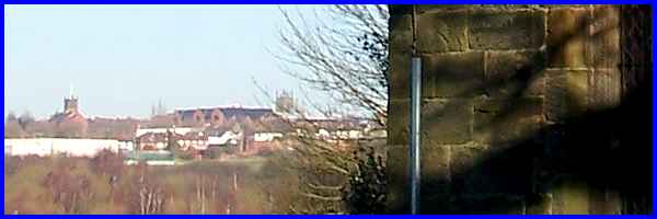
Looking to the north however from the foot of the tower at Kirk
Hallam, two more churches that mark the end of our journey, the
URC with its green spire on the left and the tower of St Mary's
towards the centre, are easily distinguishable in the distance.
|
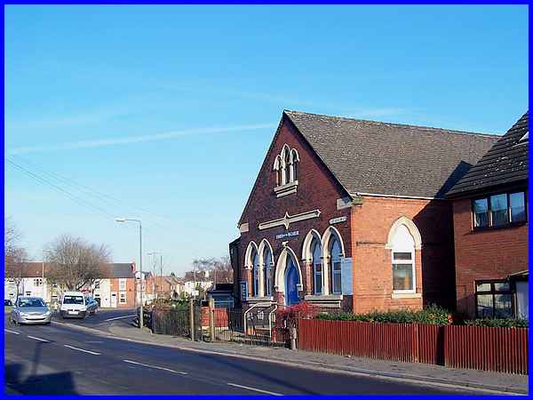
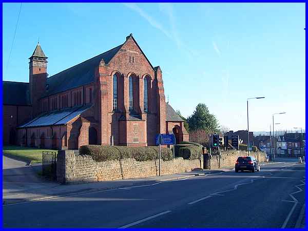
Our first port of call though is the Church of the Nazarene on
Corporation Road, seen here looking towards The Triangle on the
left and Thurman Street leading through to Nottingham Road. The
Church of the Nazarene was founded in South Street premises in
1940 and didn't move to Corporation Road until 1964 when it took
over the former Wesleyan Church.
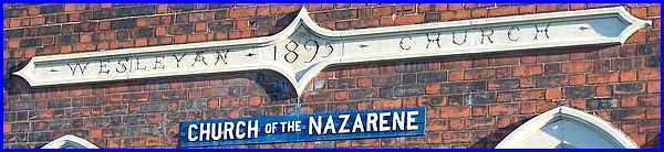
Flanked by buildings from a more recent era, the stonework reveals
that the church was originally built in the 1890s. I think that
the date shown is 1895 but elsewhere it is recorded that the
church was built in 1893.
|
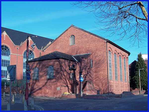
At the end of Adam Street, a short un-adopted road off the bottom
of Nottingham Road is "A Church of Christ" which meets
in this unpretentious brick building. The website of the Churches
of Christ proclaims that "We are undenominational and have
no central headquarters or president. The head of the church
is none other than Jesus Christ himself" and "We are
Christians only!"
|
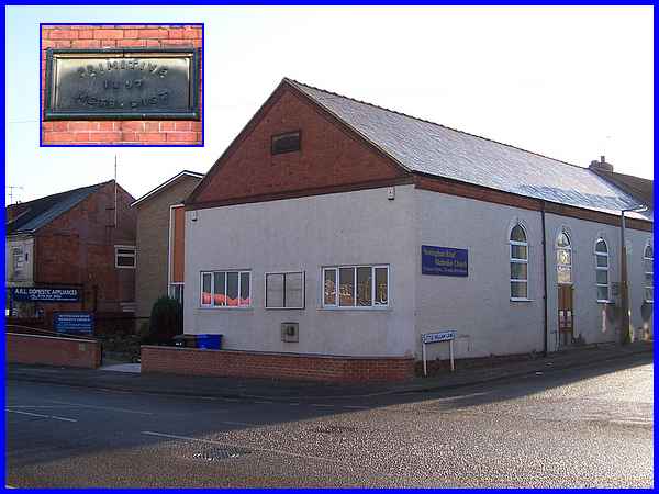
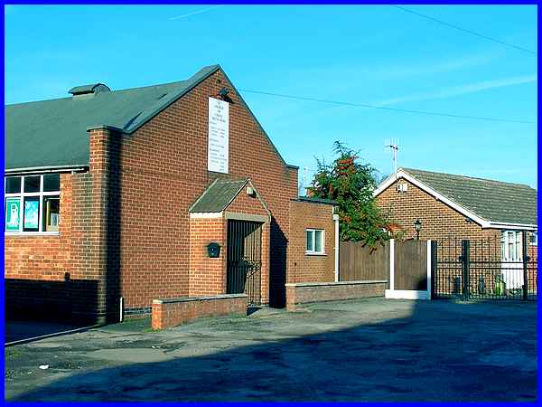
Also on Nottingham Road but on the opposite side to Adam Street
is the Nottingham Road Methodist Church. The church is comprised
of two connected buildings, a new structure (1959) standing back
from the road and an older one on the corner of Little Hallam
Lane.
The corner building has a number of inscribed foundation stones
(right) at ground 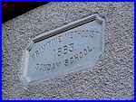 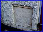 level but the wording
has worn and they are difficult to read. Higher up however another
stone (left) reads "Primitive Methodist Sunday School"
and carries the date 1883. This can be a little confusing for
on the same building on the gable end another inscribed stone
also bears the words "Primitive Methodist" but the
date is 1897. This can be explained by delving into the history
of the church a little deeper. level but the wording
has worn and they are difficult to read. Higher up however another
stone (left) reads "Primitive Methodist Sunday School"
and carries the date 1883. This can be a little confusing for
on the same building on the gable end another inscribed stone
also bears the words "Primitive Methodist" but the
date is 1897. This can be explained by delving into the history
of the church a little deeper.
Migrant families from Staffordshire attracted to the area by
work at the nearby Trowell Forge started the church in 1875 when
four cottages on the site were purchased, one being used for
public worship. A purpose built church was erected (1883) in
the gardens of the cottages and opened in 1884, which explains
the date of the first stone. In 1897, the second date, two of
the cottages were demolished and the church extended.
|
It must have been about the same time that thoughts were being
formed about extending the Methodist Church that the foundation
stone for St John The Evangelist's Church a little further up
the hill on Nottingham Road was being laid. This occurred in
1893 and the brick building in the Early English style to a design
by Percy H Currey of Derby was dedicated in 1894 by the Bishop
of Southwell. It took almost another twenty years though before
the church was finally completed in 1911 for initially being
built as a chapel of ease to St.Mary's, it became the parish
church of the newly formed St John's parish in 1912.
|
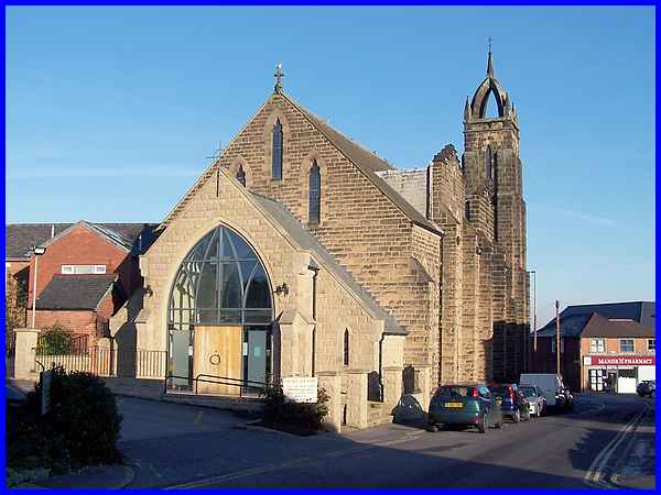
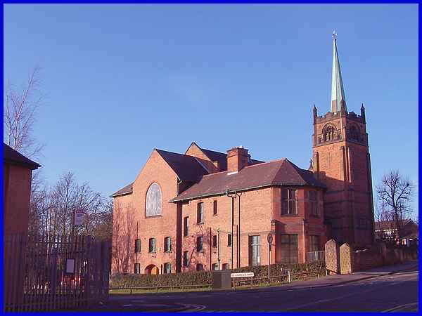
Still further up the hill and built on the corner of Nottingham
Road and Regent Street is the Catholic Church of Our Lady of
Dale and St Thomas of Hereford. St Thomas of Hereford was a member
of the Cantelupe family, the Cantelupes being Lords of the Manor
in the 12 and 1300s but whose name has travelled down the centuries
and can still be found in Ilkeston today - for example, Cantelupe
Road and Cantelupe Centre next to St Mary's Church on the Market
Place.The entrance to the Roman Catholic Church above is from
Regent Street and the porch is a recent modification to the original
building from the 1920s and 30s. A shortage of funds in the mid
1920s prolonged the construction which was around an older church
on the site. It was built mainly of Darley Dale stone with a
slate roof in the Early English Gothic style to Charles W Hunt's
design with the tower being the final piece of the jigsaw.
|
As we now move nearer the town centre we'll pass the old chapel
building on South Street that dates from 1784. Currently it is
being used as a public house called "The Hop" but it
was built for a Baptist congregation from the Little Hallam area
of Ilkeston. As the church grew it needed extra premises and
a plot of land on Queen Street was purchased where a new four
hundred seater chapel was built in 1858 (above).
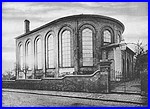 Designed by Mr Booker of Nottingham
and built by Jedediah Wigley of Ilkeston, the capacity was increased
by another hundred when a gallery was added in 1883. The design
of the building, now Grade II Listed, included a semi-circular
east end, seen at its best in this old photo (left) but it did
not meet with universal approval when first built. A local newspaper
report likened it to an engine shed and said that it was not
at all attractive adding that “some people think it positively
ugly and repellent.” They should see some of the buildings
put up today! Designed by Mr Booker of Nottingham
and built by Jedediah Wigley of Ilkeston, the capacity was increased
by another hundred when a gallery was added in 1883. The design
of the building, now Grade II Listed, included a semi-circular
east end, seen at its best in this old photo (left) but it did
not meet with universal approval when first built. A local newspaper
report likened it to an engine shed and said that it was not
at all attractive adding that “some people think it positively
ugly and repellent.” They should see some of the buildings
put up today!
|
In the previous image of Queen Street Baptist Chapel the large
building behind is a mulit-storey car park. This is one new building
that did pay attention to existing architecture as it was inspired
by the United Reformed Church that stands opposite on the corner
of Albert Street and Wharnclife Road.
  Built as a non-conformist
church in 1904 and opened in 1905, it is described as being in
the Art Nouveau Gothic style and was designed by Harry Tatham
Sudbury, a local man who was responsible for many buildings in
the town in the early part of the twentieth century. It is to
the credit of both the architect and also the builder, another
Ilkeston man Alfred Earnshaw of Burr Lane, that the church and
attached school rooms have added to the town's heritage gaining
Grade II Listed status. Built as a non-conformist
church in 1904 and opened in 1905, it is described as being in
the Art Nouveau Gothic style and was designed by Harry Tatham
Sudbury, a local man who was responsible for many buildings in
the town in the early part of the twentieth century. It is to
the credit of both the architect and also the builder, another
Ilkeston man Alfred Earnshaw of Burr Lane, that the church and
attached school rooms have added to the town's heritage gaining
Grade II Listed status.
|
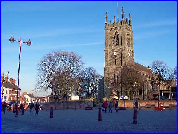
And so we finally reach the Market Place and the Parish Church
of St Mary where a number of names we have already encountered
reappear. The Cantelupe Centre stands to the right and is connected
to the church whilst the tomb of a Lord of the Manor, Nicholas
de Cantelupe is in the church itself. Originally built in 1154
by an earlier Lord of the Manor, Robert de Muskham it is now
mainly of the Victorian era being extensively restored between
1853 and 1855 by T L Walker. Just over half a century later,
Percy Currey, the designer of St John's on Nottingham Road, was
also responsible for the extension to the nave at St Mary's that
involved dismantling the tower in 1910 and rebuilding it brick
by brick forty-five feet to the east and closer to the Market
Place. Back in the 1700s the tower had been surmounted by a spire
until struck by lightning in 1714 and if it had one now its Grade
II* listed status would probably be even higher.
So that concludes the second set of images of the places of worship
in Ilkeston and in case you were still wondering I make the total
number nineteen .... unless of course you know of any I've missed.
Click here to see the first set of ten in the northern
half of the town.
|
