Draycott & Wilne - Part 01 - Station Road Approach
w/e 05 August 2012
All this week's pictures were taken
with a Kodak DX6490
Preamble: In the 1990s a number of leaflets were
published by a variety of organisations including Erewash Borough
Council, Groundwork, various Parish Councils and some private
companies. These leaflets featured Country Walks, Family Walks
and Village Trails and I collected as many of them as possible.
A few of them have been reprinted but the copy of the Draycott
and Wilne Village Trail I hold is dated 1997 so much may have
changed in the intervening fifteen years. It is this leaflet
though that I will be using as the basis of this series as we
take a leisurely look at both villages.
Introduction: The leaflet describes a route from the middle of
Draycott down the lane to Wilne and then back again following
part of the same route we walked recently in the Coffin Walk
along the Derby Canal. Rather than repeat that part of the walk,
I've devised a route of my own route. The Coffin Walk started
from Breaston and touched the edge of Draycott approaching from
the south. For this Village Trail therefore we will again approach
from Breaston but this time along the main road from the east.
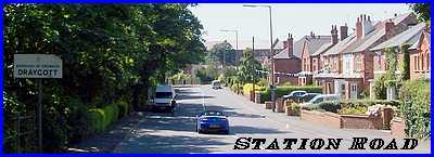
The railway line separates Breaston from Draycott so we'll begin
where Station Road descends from the railway bridge near the
former station site.
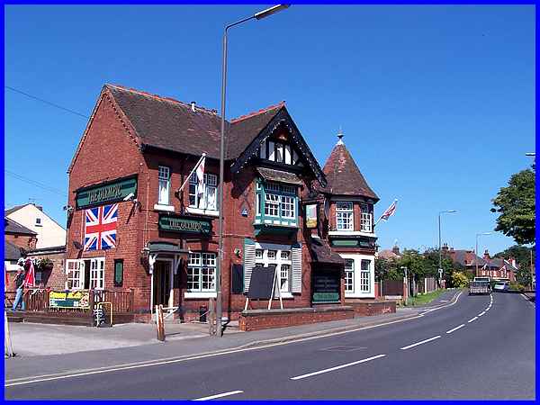
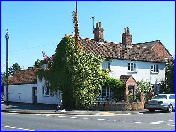
And looking back towards Breaston it is fitting that we begin
the walk in the middle of the London Olympic games at the Olympic
pub. Dating from the mid-19th century the pub was renamed in
1953 being known previously as The Draycott Hotel. One of the
services offered by the hotel when steam trains and coach and
horses were the order of the day was to offer lifts along Station
Road to the railway station.
|
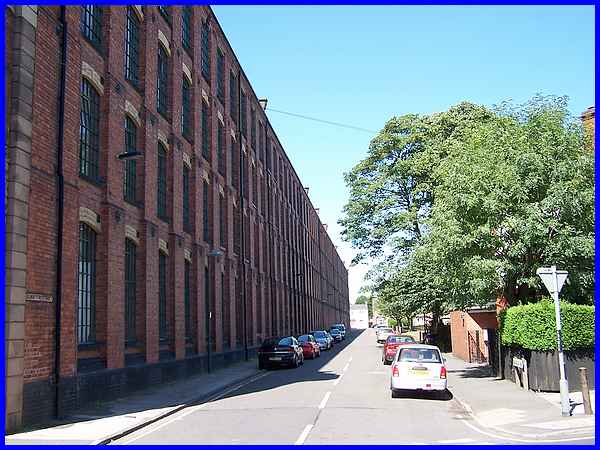
By far the most imposing building in Draycott and seen from all
around across the flat landscape is the one that housed the Victoria
Mills. the four storey lace factory was built in two phases from
1888 by Terrah Hooley. The length of the building seen along
Edward Street from Station Road gives an idea of the actual size
of the structure which is likened to the size of Noah's Ark.
In Biblical terms it is 300 cubits long by 50 cubits wide and
30 cubits high.
|
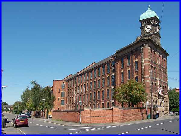
The length of the mills from the other side along Town End Road
is not as apparent but from here it is possible to view the fine
Italianate frontage topped by the ornamental clock tower. The
cupola was added in 1907 when the building was the largest lace
manufacturing mill in Europe. The extended factory was opened
by its owner Mr. Jardine whose name is still visible today in
the stonework immediately beneath the clock. Mr. Jardine also
shared some of his wealth with the children of the village by
depositing one shilling (5p) in a savings account for each child.
Fifteen years ago (when the leaflet was printed) the mill was
owned by W. J. Parry (Nottm) Ltd and was supplying electrical
components from the premises which they had been doing since
1948. Today the Station Road end of the building has been converted
into apartments but the rest the old mill stands empty. With
the pressure on local councils by central government to find
sites for housing development, maybe the development of the rest
of the Victoria Mills is one that should be considered.
|
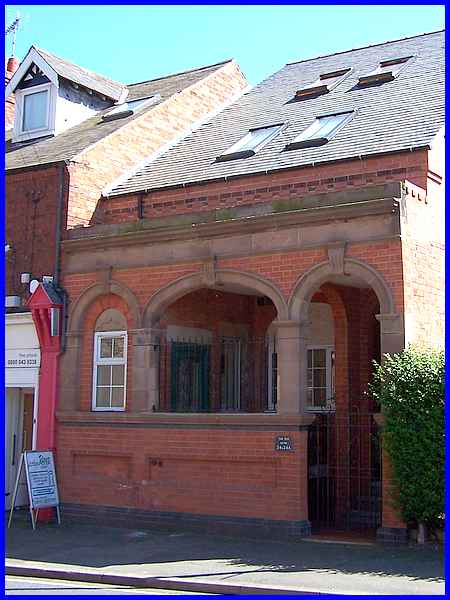
Directly across Station Road from the Victoria Mills is a building
that was purpose built as an architect's office in the early
1900s. The architect was a Mr Antliff who designed the Methodist
Chapel in the neighbouring village of Borrowash. In 1997 the
leaflet tells us that the building was used as a meeting point
for older people in the village but a plaque on the wall indicates
it was "The Old Bank" and now, after conversion work,
provides residential accommodation.
|
Station Road (to the left) becomes Victoria Road at the junction
with Sawley Road (ahead) and it is at this junction that the
Impounder of Draycott kept any stray animals in the pinfold on
a triangle of land. Sawley Road/Victoria Road were part of the
straight Roman road that was built to transport lead from Derby
to the River Trent at Trent Lock and it was here in this "dry
place" that the village of Draycott grew up. Various spellings
of the name have been used over the years including Draicott,
Dry Cote, Draycotte and Draycote. Alternative meanings associated
with the name are "the place where the boats were dragged"
and "the shede where drays were kept".
|
Lodge Street also meets almost at the same junction. In fact
side of the corner house on Lodge Street actually runs along
Sawley Road. The cottage itself is now known as "The Old
Forge", a reference to when outbuildings at the rear housed
the blacksmith's shop. The leaflet makes mention here of an old
sewer vent pipe and although we searched for it were unable to
find it. Putting it down to one of the changes that had occurred
some time during the last fifteen years, we assumed it had been
removed. It was only when reviewing the images on returning home
that I noticed the pole on the left with the ornate top that
I realised that what I was looking at was in fact the said pipe.
Surely a case of "looking" at something on site but
now actually "seeing" it. I now know why the phrase
"You can't see the wood for the trees" came into being!
|
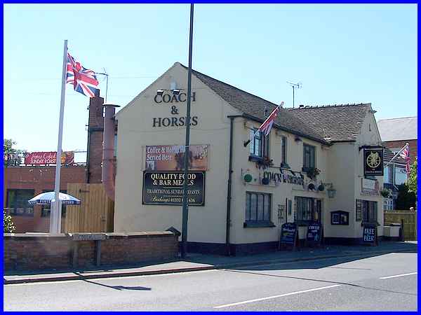
Across Lodge Street facing onto Victoria Road is the Coach and
Horses inn which records show that it had its own carriage house
and stable back in 1842 making it one of the oldest of the current
inns in the village. It was previously called the Old Coach and
Horses. Although modernisation and alterations to the original
building have taken place the oldest part still remaining dates
from the late eighteenth century.
|
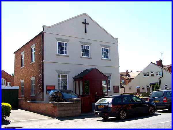
Another old building close to the Coach and Horses on Victoria
Road is the former Methodist Chapel of 1830. The Wesleyan congregation
moved out in 1966 to join the Primitive Methodists in Market
Street forming the Draycott Methodist Church and this building
became the home of St Mary’s Church which was founded elsewhere
in 1928 as a chapel of ease of St Chad's Church at Wilne.
This is where we'll leave the first part of this Village Trail
but will return further along Victoria Road later. Backtracking
a few steps we'll begin the second part of our look at Draycott
along Lodge Street.
|
