 This project has
been simmering on the back burner for a long time and has been
planned for even longer. It all started when I picked up a leaflet,
as I am wont to do, probably in our local library. At least I
think that's where I obtained it but it is so long ago that I
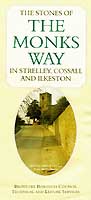
cannot be sure. It was titled "The Stones of the Monks Way
in Strelley, Cossall and Ilkeston" and was published by
the Broxtowe
Borough Council Technical and Leisure Services Department. This project has
been simmering on the back burner for a long time and has been
planned for even longer. It all started when I picked up a leaflet,
as I am wont to do, probably in our local library. At least I
think that's where I obtained it but it is so long ago that I
cannot be sure. It was titled "The Stones of the Monks Way
in Strelley, Cossall and Ilkeston" and was published by
the Broxtowe
Borough Council Technical and Leisure Services Department.
Broxtowe lies to the east of the River Erewash and the leaflet
opened up to display the route of a walk from Strelley Village
westwards across the river to Ilkeston and the Borough of Erewash.
I was immediately intrigued as the route, except for a visit
to the Erewash Museum in the centre of town, finished less than
fifty yards from my home. This was worth investigating I thought
and so my mission to explore the route armed with camera started.
Little did I know at that time where it would lead and how
long it would take to reach this point in time where I can start
to share some of the images - and the legends and history of
the Monks Way. I have had the majority of the images for some
time but I was daunted by the thought of putting them into some
sensible sequence and how best to present the project. For far
too long I have been trying to visualise the end product whereas
we all know that the only way to climb a mountain is one step
at a time. So at long last, I have taken it off the back burner
and made a start in putting something together.
It will be apparent from what I have written here that the
photos were taken over quite a considerable period in all weathers
and in all seasons too. When I upload the pages to the internet
on a monthly basis, the images will not necessarily be in tune
with the 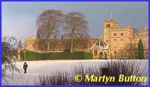 actual
season but this is the plan. Referring to the map towards the
top of this page you will see two distinct routes. First there
is a roughly north-south route between Newstead Abbey and Lenton
Priory (shown dotted red) and then an east-west route from Strelley
to Ilkeston (yellow) which continues as a red dotted line to
Dale Abbey. The first sections of the project will look at Lenton,
Beauvale and Felley before returning to Strelley to follow in
greater detail the route to Ilkeston. The final part of the project
will then move to Dale. I have decided not to include Newstead
Abbey in the scope of the project save for the inclusion of the
images on this page taken by, and reproduced here with the permission
of a good friend Martyn Button (Calverton Cam). Other web sites already cover
Newstead in some detail. actual
season but this is the plan. Referring to the map towards the
top of this page you will see two distinct routes. First there
is a roughly north-south route between Newstead Abbey and Lenton
Priory (shown dotted red) and then an east-west route from Strelley
to Ilkeston (yellow) which continues as a red dotted line to
Dale Abbey. The first sections of the project will look at Lenton,
Beauvale and Felley before returning to Strelley to follow in
greater detail the route to Ilkeston. The final part of the project
will then move to Dale. I have decided not to include Newstead
Abbey in the scope of the project save for the inclusion of the
images on this page taken by, and reproduced here with the permission
of a good friend Martyn Button (Calverton Cam). Other web sites already cover
Newstead in some detail.
Before we start our journey, it is worth relating a little
of the history and origin of the Monks Way although much is shrouded
and lost in the mists of time. What is known as fact is that
Lenton Priory was founded shortly after the Norman Conquest,
being one of 150 religious houses erected during the reign of
Henry I. It belonged to the Cluniac Order of Monks and with endowments
from towns and villages in Nottinghamshire, Derbyshire, Yorkshire
and Leicestershire it became the wealthiest Priory in the Midlands
and the tenth richest in England. It is also known that between
twenty and thirty monks were normally in residence at any one
time and during its 430 years of existence close on one thousand
men passed through its cloisters. Several reigning Monarchs visited
and were entertained at the Priory including Henry II in 1230,
Edward I in 1302 and 1303, Edward II in 1307 and 1323 and Edward
III in 1336 and several times thereafter. So it can be seen that
Lenton Priory was an establishment of some importance.
Monks from Lenton and other monasteries and religious house
in the area including Newstead Abbey had land and mining interests
as early as the fourteenth century and it is not 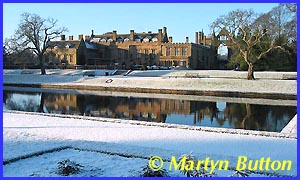 unreasonable
to assume that paths connected these holdings to facilitate trade
and communication. Packhorses and mules were common methods of
transport and the paths often linked to rivers. Later development
of canals, railways and roads often obliterated these ancient
paths and causeways but remnants of one such route can still
be determined between Strelley and Ilkeston on what I am now
referring to as the "Monks Way". Other terms used to
describe the causeway are Monks Path, Monks Steps and Pilgrims
Path but whatever you choose to call it, the stones of the path
are visible in several places and images of them will appear
in later parts as this project progresses. But that's enough
of the history for now so let's make a start and begin our journey
and exploration in what is now a suburb of Nottingham but what
was once the village of Lenton near the site of the great mediaeval
Priory. unreasonable
to assume that paths connected these holdings to facilitate trade
and communication. Packhorses and mules were common methods of
transport and the paths often linked to rivers. Later development
of canals, railways and roads often obliterated these ancient
paths and causeways but remnants of one such route can still
be determined between Strelley and Ilkeston on what I am now
referring to as the "Monks Way". Other terms used to
describe the causeway are Monks Path, Monks Steps and Pilgrims
Path but whatever you choose to call it, the stones of the path
are visible in several places and images of them will appear
in later parts as this project progresses. But that's enough
of the history for now so let's make a start and begin our journey
and exploration in what is now a suburb of Nottingham but what
was once the village of Lenton near the site of the great mediaeval
Priory.
|